English   Română   Español   Français   Deutsch  

getamap.net

Afrique

Oceanie

Asie

Amerique du Nord

Europe

Amerique du Sud

L'Antarctique


14°19'60" S
178°3'0" W
~5m asl
05:57 (WFT - UTC/GMT+12)

Chenal Sain (Chenal Sain) est un/une canal maritime (class H - hydrographique) en Wallis and Futuna (general), Wallis Et Futuna [ France ] (Oceania), ayant le code de région Americas/Western Europe. Chenal Sain est situé à 5 mètres d'altitude.

Les coordonnées géographiques sont 14°19'60" S et 178°3'0" W en DMS (degrés, minutes, secondes) ou -14.3333 et -178.05 (en degrés décimaux). La position UTM est CE81 et la référence Joint Operation Graphics est SD01-10.

L’heure locale actuelle est 05:57; le lever du soleil est à 08:53 et le coucher du soleil est à 21:00 heure locale (Pacific/Wallis UTC/GMT+12). Le fuseau horaire pour Chenal Sain est UTC/GMT+12
En 2024 l’heure d’été est valable de - à -.

A Canal maritime est la partie d'un plan d'eau assez profond pour la navigation dans une région par ailleurs ne convient pas.


Country
 Advertisements:


 Advertisements:


Météo Chenal Sain (Nébulosité, Température, Vent et Précipitation mm probab.)

Mon


Apr 29
Clound 40-10-0-10 Lightning
~3 l/m2 38%
 
29 °C min
30 °C max
31 km/h
Thu Jan 1

Tue


Apr 30
Clound 20-10-0-40
~3 l/m2 36%
 
28 °C min
30 °C max
22 km/h
Thu Jan 1

Wed


May 1
Clound 30-10-0-20 Lightning
~7 l/m2 54%
 
28 °C min
30 °C max
29 km/h
Thu Jan 1

Thu


May 2
Clound 40-10-10-60 Lightning
~12 l/m2 53%
 
29 °C min
30 °C max
31 km/h
Thu Jan 1

Fri


May 3
Clound 30-10-0-70 Lightning
~9 l/m2 60%
 
28 °C min
30 °C max
32 km/h
Thu Jan 1

Sat


May 4
Clound 40-10-0-40 Lightning
~11 l/m2 48%
 
28 °C min
29 °C max
21 km/h
Thu Jan 1

Météo Graph

Chenal Sain (Wallis and Futuna (general)) prévisions à 7 jours
 

Carte et Les photos Chenal Sain


Commentaires

--- Il n'y a aucun commentaire ---


Ajouter un commentaire:


Vous devez vous connecter pour ajouter un commentaire!


Login


Register

Mot de passe oublié ?

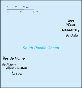
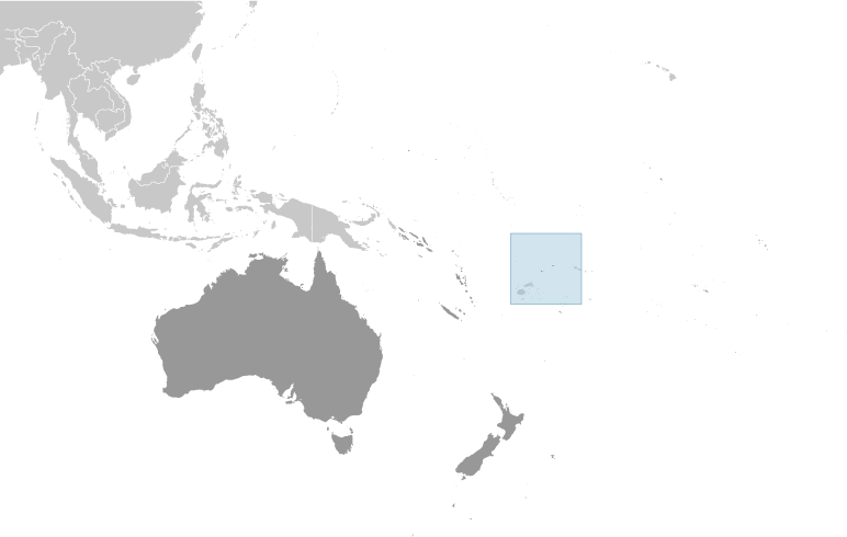
Wallis Et Futuna [ France ] (Overseas Territory):

Advertisement


Points GPS pres de Chenal Sain


square Alofitai (1 km)

square Mua (1 km)


square Vele (2 km)

square Pointe Vele (2 km)

square Alofa (2 km)

square Ile Alofi (2 km)


square Mont Kolofau (2 km)

square Green Point (3 km)

square Pointe Verte (3 km)

square Iles Futuna (4 km)


square Iles de Hoorn (4 km)


Points GPS de Wallis Et Futuna [ France ] (Overseas Territory)

square Nukuatea Island Wallis And Futuna (general)

square Lanumaha Wallis And Futuna (general)

square Ile Fenua Fu Wallis And Futuna (general)

square Foss Reef Wallis And Futuna (general)

square Pointe Pagaga Wallis And Futuna (general)

square Banc Safiafi Wallis And Futuna (general)

square Taviuni Bank Wallis And Futuna (general)

square Ile Futuna Wallis And Futuna (general)


viewweather.com sv.ViewWeather.com
fr.ViewWeather.com
da.ViewWeather.com
de.ViewWeather.com
es.ViewWeather.com
www.carpati.org
www.searchromania.net
Deblocari usi
es.getamap.org
fr.getamap.org
de.getamap.org
nl.getamap.org
da.getamap.org
www.getamap.org
Liens
Conditions d'utilisation
Politique de confidentialité

# 0.9050 sec 

contact AT getamap.net

© 2006 - 2024  https://fr.getamap.net/